CLUG Projects: Challenges for GNSS in the railway environment
Several factors are affecting GNSS in the railway environment, and they need to be acknowledged in a CENELEC conform process. Some of the GNSS feared events to be considered are listed below:
- Multipath: A multipath error occurs when a GNSS signal is reflected, such as the wall of a building. If this reflected signal can be tracked by the receiver, this results in a ranging error of the distance between receiver and satellite. Normally one distinguishes two different types of multipath which apply to code and the carrier phase: Line of sight or Non-line of sight.
- Interference/Jamming: GNSS signal can be intentionally (Jamming) or non-intentionally (Interference) disturbed, which is a major issue now a days. These feared events occurs when intentional or unintentional the GNSS signals are made unavailable. For example with a quite cheap and easily available jammer, within seconds GNSS signals can be made unavailable and can cause critical situations when rely only or mostly on GNSS signals for their service. Unintentional jamming occurs in Band and out of Band frequencies and can degrade of GNSS signals. Fixed VHF communications, harmonics of television stations, certain radars, mobile satellite communications, and military systems are source of unintentional jamming signal.
The effects of these events can be affected either in probability or impact depending on the surrounding environment of the train:
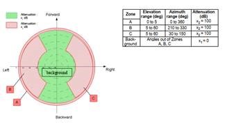
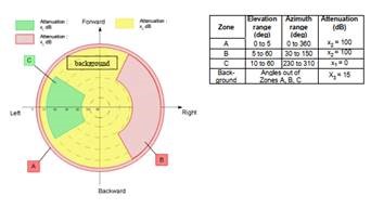
- Settled regions: Typically, in settled regions, the probability for interferences due to man-made RF-signal sources, as well as for multipath due to signal reflection on buildings is generally higher. The denser the region is settled, the greater the probability. The worst case of this environment can be found in the traditional highly populated urban area (e.g., Frankfurt, New York). Additionally, the satellite view in this environment is obstructed on a low till extreme level due to man-made constructions which can also generate multipath effects for example. In the ETSI TS 103 246 -3 V1.3.1 (2020-10) some examples of the sky attenuation conditions are described which can be used to simulate this environment (see figure 1 and 2). Due to the reduced visibility of satellites and reduced signal strength several effects like an increased measurement noise can be expected, which results in reduced accuracy. In serious cases a non-availability of GNSS- based positioning is possible.


- Mountain and valleys: Interference sources occur with a lower probability in this kind of environment, but multipath effects are still common. As for the settled regions, the limitations in terms of satellite visibility are considerable but on the other hand also heavily dependent on the specific topographic features of the specific area (e.g., the position of higher mountains). The biggest issue can be found directly on the mountain flanks and in valleys. The effect intensifies as the terrain gets steeper. The satellite view is up to a certain level similar to settled region. Thus, the sky attenuation conditions described in Figure 1 and Figure 2 can be used for simulation purposes. Due to these similarities, the effects also resemble, and thus an increased measurement noise can be expected, which results in reduced accuracy. In serious cases a non-availability of GNSS- based positioning is possible.
Based on the experience gained in the past years, GNSS can be considered as an important technology for safety and non-safety relevant railway applications.
Because of several challenges like stated above, an assessment based on laboratory experimentation is essential. And these events and environments need to be fully acknowledged within a CENELEC conform process leading to certification.
Within the CLUG project, the highlighted events and environments are acknowledged in an extended setup in the analysis, testing and prototypical certification process.


