

CLUG Projects: Required Digital Map for Localisation
The specification work is being performed in the Work Package 5.2 under the leadership of DB Netz as part of the sector initiative "Digitale Schiene Deutschland” and with the contribution of CAF, ENAC, NAVENTIK, NavCert, SBB, Siemens Mobility and SNCF. The specification document will be published as deliverable 5.4 in May 2022.
The purpose of the document is to define a comprehensive definition of the digital map (DM) needed by the train localisation system on the air gap between trackside and the train. The primary goal of the DM specifications is to meet the CLUG High Level System Requirements defined in Work Package 2.3.Beside the CLUG context an alignment with all map related Reference CCS Architecture (RCA) [1] activities especially from the Digital Map Cluster is mandatory.
General
The DM provides the mandatory information for the localisation algorithm: Track centerline points with dynamic distances to describe the track layout in 3D coordinates.
The DM is designed to be universally extendable with its layer structure and data model (node-edge-model). The DM design also prevents redundancies.
DM Content
For the localization algorithm the following information is required:
- Logical relationship of infrastructure objects to each other within the railroad network (à node-edge-model)
- Absolute positions of track centerlines, e.g. points determined by GNSS measurement
For the localization algorithm the following information could be considered:
- Balises represented by their distance to the start of the current TrackEdge, IDs and country codes
- Curve radius as points where the value changes for the upcoming TrackEdge segment
- Cants as points where the value changes for the upcoming TrackEdge segment
- Gradients as points where the value changes for the upcoming TrackEdge segment
DM Data model
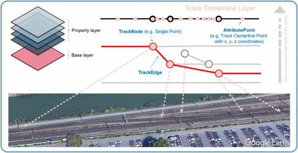
The CLUG map data model has been derived from the RCA Topology domain [2] and is reduced to a minimum required set of objects for the localisation use cases in CLUG: TrackNodes, TrackEdges and AttributePoints.
TrackNodes:
A TrackNode is a position on the topological model of the track network. It defines the beginnings (Side A) and endings (Side B) of TrackEdges. There are three different situations which are modelled with TrackNodes: Points, track ends, Country / RBC / station boundaries.
TrackEdges:
A TrackEdge represents one piece of one track (i.e. not a double track line) which really exists including its real length. A TrackEdge always connects exactly two TrackNodes. TrackEdges are directional: Side A à Side B = Nominal, Side B à Side A = Reverse.
AttributePoints:
An AttributePoint represents
- Reference points with absolute coordinate to map the track axis
- Track elements, e.g. balises
- Main points of the track geometry, e.g. curvature radius changes
The AttributePoint values are always dependent from the direction. This dependency is directly connected to the direction of the TrackEdge.
[1] Reference CCS Architecture (RCA) - https://ertms.be/workgroups/ccs_architecture (Last access: 2021-12-21)
[2] RCA: RCA Domain Knowledge (Preliminary Issue), RCA.Doc.18, v 0.3, 02.06.2021
Henning Nitzschke, WP 5.2 lead and digital maps expert within CLUG, Product Owner DR (Automated Rail@DKS) within DB Netz